Elevation gain: 3325'
Trails used: West Slopes of Mount Bierstadt, North Table Loop, Tilting Mesa, Lichen Peak
The second hike of the week, which I decided to do on a Saturday. Big mistake, even though I left the hotel at 5 a.m. I was still late to the party. Oh, and what a party it turned out to be...
To reach the trail head I would use to climb Bierstadt, I drove I70 to the Georgetown exit and followed the signs to the Guanella Pass Scenic Highway and it was very scenic. There are camp sites that surround the pass, and wildlife galore. I saw several deer mule, and bighorn sheep on the drive up.
Mount Bierstadt's claim to fame is that it's one of Colorado's easiest Fourteener's and its close proximity to Denver makes it even more appealing. It is also Colorado's 14th highest ranked peak. It is located in Clear Creek County and is part of the Central Front Range.
The weather was a tad overcast to start and a bit windy and cool.
The view of Mount Bierstadt from the parking area/road and just before the Guanella Pass Trail Head. To the left of Bierstadt is The Sawtooth.

To protect this willow wetlands area, they built boardwalks through it so hiker's weren't thrashing around in the vegetation. Problem is, it's located in a Wilderness area and we all know about Wilderness rules.

A little ways into the hike, I looked back for this view. You can clearly make out the line of cars that were parked on both sides of the road. Both lots were full too.

Still moving through the willows. I passed group upon group of hiker's making their way up at different paces. I knew it would be a busy hike with how jam packed parking was already at 7 a.m.

If you look closely, you can see all the people snaking their way up the lower ridge.

The trail work was absolutely well done. The trail to just below the summit was a Class 1 trail.

The sun was starting to come out more so I got this picture of Mount Bierstadt. As before, if you look closely you can see the horde of people heading up.

Looking across the Scott Gomer drainage to impressive views of The Sawtooth.

It never felt like it was too steep as there were ample switchbacks throughout the hike.

With extensive views like these, who couldn't love hiking here?


Still climbing. Just before the false summit push to the actual summit of Mount Bierstadt. It is still a Class 1 trail to this point.

A snow field right below the summit of Mount Bierstadt.

It's a party on the summit of Mount Bierstadt (elevation 14060'). There were more people on the other side of the summit, with probably about 75-100 people total in one little area.

Panorama view from the summit of Mount Bierstadt.

Looking over to the summit of Mount Evans, another fourteener that is the closest to Denver and has a paved road almost to the summit.

Look, another register on the summit! There is actually two up here, the other was damaged, hence the second cap below.

A picture from the summit of Mount Bierstadt of The Sawtooth, which is the ridge you can cross between Bierstadt and Mount Evans and is considered Class 3. I had considered doing the traverse but upon hearing several people had died attempting the traverse, and being solo, I decided smartly to head back the way I came and not chance this.

Looking southwest from the summit to Abyss Lake down below.

More decent views from just below the summit. With so many people, I am surprised there weren't more people in them.

Looking back at all the people going up to the summit of Mount Bierstadt.

Hey you! What are you doing over there? Well, I am hiking IN Colorado now.....

I almost forgot why I took this picture. Can you guess why?

You want people? You got people. Look closely and you can see quite a few. This is looking back towards the west ridge of Mount Evans and the Scott Gomer drainage.

Not a clue what these are; they just looked interesting.

More people and views. I would imagine, and this is just a guess, I passed about 1000 people going up and coming down from the summit.

Who let the goats out? Who, who, who, who......


Once off the switchbacks, the hike out was more of a stroll than an actual hike.

Almost back to the trail head parking area. Pleasant walking at this point.

Splendid views abound. The scenery is almost too much to take in sometimes.

The trail head area. I walked down with a gentleman named Jim who used to live in New Hampshire years ago. It was nice chatting with him about New Hampshire and his new home in Colorado. At the trail head, they were doing survey's on trail maintenance and the girl talking to Jim was from New Hampshire. Crazy.

An inaccurate representation of the amount of cars that were parked in the parking lots and along side the road. Think of the Franconia Ridge parking lot on a nice day, and times that by like 10. That's ALOT of cars.

Not content with finishing early, I decided to attempt another hike. I could see storms off in the distance when I was coming down off Mount Bierstadt, but I would chance it anyways. I had read about a hike located in Golden, Colorado that I could do, and it wasn't terribly long so off I went.
North Table Mountain is a mesa located in Jefferson County, Colorado that has a twin mesa, South Table Mountain nearby. There are about 15 miles worth of trails here, as well as some rock climbing areas.
The kiosk with the map of the mesa at the trail head, off of Highway 93.

You start the hike off on the North Table Loop Trail which is basically a road that you walk up to the top of the mesa. I also saw several people mountain biking up.

Looking down to parts of Golden, Colorado. An approaching thunderstorm had me constantly glancing back over my shoulder to keep tabs on which way it was moving.

The "trail" going up (okay, it's a road) was pretty straight-forward and steep.

Once on top of the mesa though, the going got easier. This is the North Table Quarry area.

The Lichen Peak Trail, a short hike over to the high point on the mesa.

Very interesting old lava formations on the way to North Table Mountain.

A panorama from the summit of Lichen Peak which is the high point of North Table Mountain (elevation 6575').
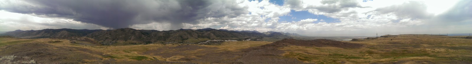
360 degree views from up on the summit of the surrounding mesa and area.


The storm was fast approaching and I could hear thunder more and more as I started to head back down to the car so the race was on.

Heading back down the Lichen Peak Trail to the North Table Quarry area.

I highly doubt anyone was climbing with the imminent bad weather.


The typical rock formations around the area. This was on the way back to the car.

A good set of hikes. Mount Bierstadt definitely does live up to it's name as a easy fourteener and a good hike for beginner's. Just make sure you get here really early (especially in the summer) as the trail head and hike will be a mad house.
I didn't get to explore the mesa more for North Table Mountain due to the bad weather, but maybe next trip back, I will do the loop hike around the park. Still not a bad day out.
Already donated but want to do more? Can't donate but still want to help? "Like" and "share" our Facebook page. Even as little as a dollar helps. Even "sharing" with just one person does too by spreading the word. Our Donation Page is set up directly through the National Multiple Sclerosis Society website, so you can donate with confidence that 100% of the money goes to this fine collection of people working to help those stricken with MS.